 Republic of Uganda: All Data
This page is about the data available for this polity; the chronology of its events is available here.
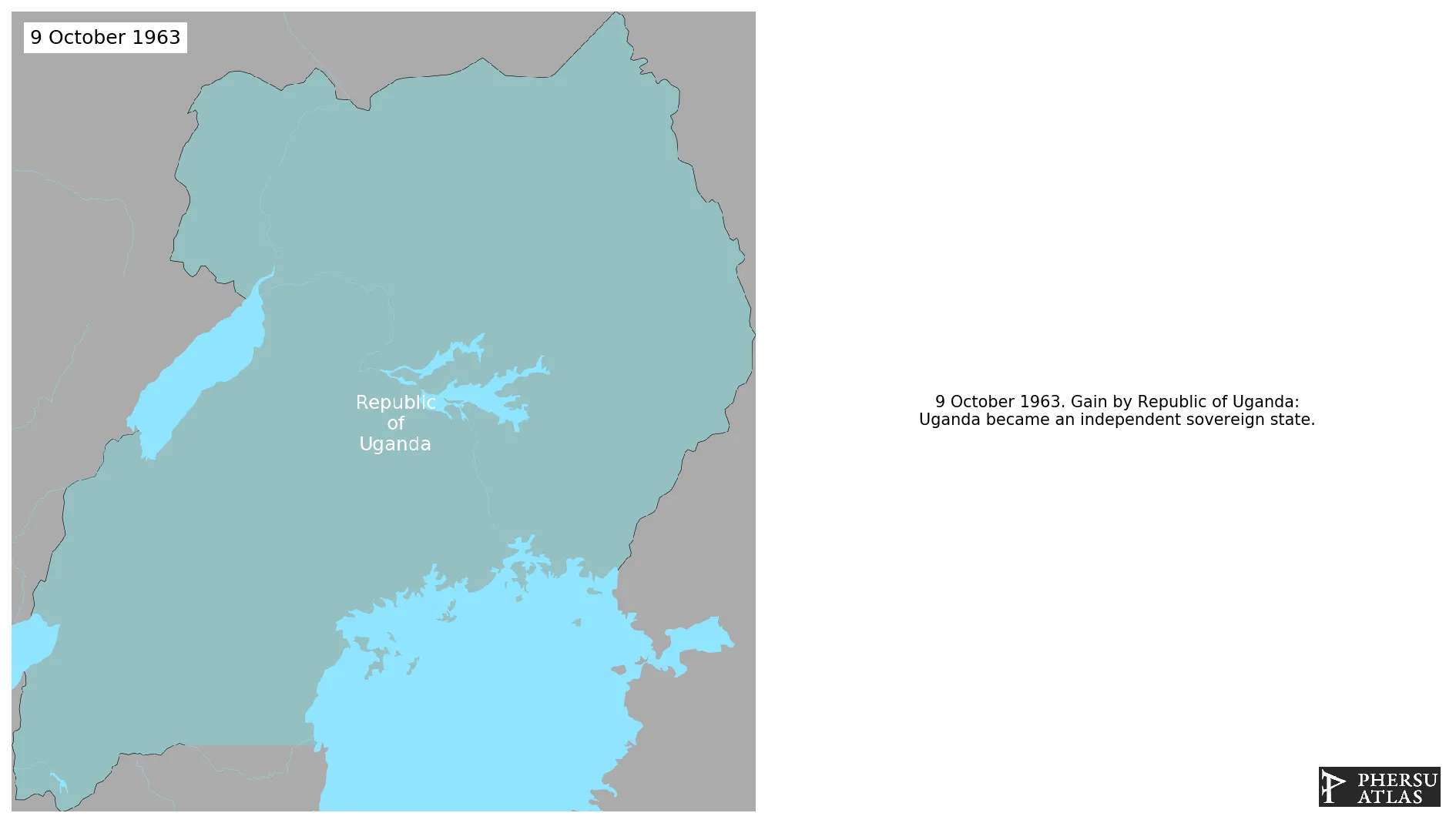
Is a landlocked country in East Africa that derives its name from Buganda, a precolonial Kingdom that occupied part of the territory of present-day Uganda. It became independent from the United Kingdom in 1963.
1. Genealogy

2. Maps of Political Control Over Time
 Republic of Uganda : Map showing the initial year each territory was ruled by the polity
Republic of Uganda : Maximal Extension of the Polity
Republic of Uganda : Map showing the initial year each territory was ruled by the polity
Republic of Uganda : Maximal Extension of the Polity
3. Administrative Divisions
4. Monthly Summaries

5. Lists and Timelines
6. Rankings
 Republic of Uganda : Top wars ordered by largest reached area
Republic of Uganda : Top wars by territorial gain or loss in terms of area of the changes
Republic of Uganda : Top wars by territorial gain or loss in terms of area difference
Republic of Uganda : Top wars ordered by largest reached area
Republic of Uganda : Top wars by territorial gain or loss in terms of area of the changes
Republic of Uganda : Top wars by territorial gain or loss in terms of area difference
7. Time Series
Republic of Uganda : Time Series of all Territorial Changes
Republic of Uganda : time series of its population and area throughout history
8. All Events mentioned in Territorial Changes

9. All Cities mentioned in Territorial Changes
 Gayaza
Lira
Tororo
Bombo
Sembebule
Lira
Adjumani
Arua
Bombo
Busia
Entebbe
Fort Portal
Gulu
Iganga
Jinja
Kaabong
Kabale
Kaberamaido
Kalangala
Kampala
Kamuli
Kasese
Katakwi
Katwe
Kayunga
Kibaale
Kiboga
Kisoro
Kitgum
Kumi Town
Lira
Masaka
Masindi
Masindi Port
Mbale
Mbarara
Mityana
Moroto Town
Moyo Town
Mpigi
Mubende
Nakasongola
Nebbi
Ntungamo
Pakwach
Pallisa
Sironko
Soroti
Tororo
Masaka
Mbarara
Lukaya
Entebbe
Bombo
Jinja
Jinja
Karuma Falls
Karuma Falls
Bombo
Entebbe
Iganga
Jinja
Kampala
Lira
Masaka
Mbarara
Tororo
Tororo
Kakuuto
Sembebule
Mbarara
Kakuuto
Kampala
Lukaya
Masaka
Entebbe
Gayaza
Lira
Tororo
Bombo
Sembebule
Lira
Adjumani
Arua
Bombo
Busia
Entebbe
Fort Portal
Gulu
Iganga
Jinja
Kaabong
Kabale
Kaberamaido
Kalangala
Kampala
Kamuli
Kasese
Katakwi
Katwe
Kayunga
Kibaale
Kiboga
Kisoro
Kitgum
Kumi Town
Lira
Masaka
Masindi
Masindi Port
Mbale
Mbarara
Mityana
Moroto Town
Moyo Town
Mpigi
Mubende
Nakasongola
Nebbi
Ntungamo
Pakwach
Pallisa
Sironko
Soroti
Tororo
Masaka
Mbarara
Lukaya
Entebbe
Bombo
Jinja
Jinja
Karuma Falls
Karuma Falls
Bombo
Entebbe
Iganga
Jinja
Kampala
Lira
Masaka
Mbarara
Tororo
Tororo
Kakuuto
Sembebule
Mbarara
Kakuuto
Kampala
Lukaya
Masaka
Entebbe