 Republic of the Congo: All Data
This page is about the data available for this polity; the chronology of its events is available here.
A country in central Africa, it gained its independence from France in 1960. It is bordered to the west by Gabon, to its northwest by Cameroon and its northeast by the Central African Republic, to the southeast by the Democratic Republic of the Congo, to its south by the Angolan exclave of Cabinda and to its southwest by the Atlantic Ocean.
1. Genealogy

2. Maps of Political Control Over Time
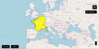
 Republic of the Congo : Map showing the initial year each territory was ruled by the polity
Republic of the Congo : Maximal Extension of the Polity
Republic of the Congo : Map showing the initial year each territory was ruled by the polity
Republic of the Congo : Maximal Extension of the Polity
3. Administrative Divisions
4. Monthly Summaries

5. Time Series
 Republic of the Congo : Time Series of all Territorial Changes
Republic of the Congo : time series of its population and area throughout history
Republic of the Congo : Time Series of all Territorial Changes
Republic of the Congo : time series of its population and area throughout history
6. All Cities mentioned in Territorial Changes
 Brazzaville
Djambala
Dolisie
Ewo
Gamboma
Impfondo
Kayes (Congo (Brazzaville))
Kinkala
Madingou
Makoua
Moloundou
Mossendjo
Ouésso
Owando
Pointe-Noire
Sembé District
Sibiti
Brazzaville
Djambala
Dolisie
Ewo
Gamboma
Impfondo
Kayes (Congo (Brazzaville))
Kinkala
Madingou
Makoua
Moloundou
Mossendjo
Ouésso
Owando
Pointe-Noire
Sembé District
Sibiti
Brazzaville
Djambala
Dolisie
Ewo
Gamboma
Impfondo
Kayes (Congo (Brazzaville))
Kinkala
Madingou
Makoua
Moloundou
Mossendjo
Ouésso
Owando
Pointe-Noire
Sembé District
Sibiti
Brazzaville
Djambala
Dolisie
Ewo
Gamboma
Impfondo
Kayes (Congo (Brazzaville))
Kinkala
Madingou
Makoua
Moloundou
Mossendjo
Ouésso
Owando
Pointe-Noire
Sembé District
Sibiti
Brazzaville
Djambala
Dolisie
Ewo
Gamboma
Impfondo
Kayes (Congo (Brazzaville))
Kinkala
Madingou
Makoua
Moloundou
Mossendjo
Ouésso
Owando
Pointe-Noire
Sembé District
Sibiti
Brazzaville
Djambala
Dolisie
Ewo
Gamboma
Impfondo
Kayes (Congo (Brazzaville))
Kinkala
Madingou
Makoua
Moloundou
Mossendjo
Ouésso
Owando
Pointe-Noire
Sembé District
Sibiti