 Republic of Chad: All Data
This page is about the data available for this polity; the chronology of its events is available here.
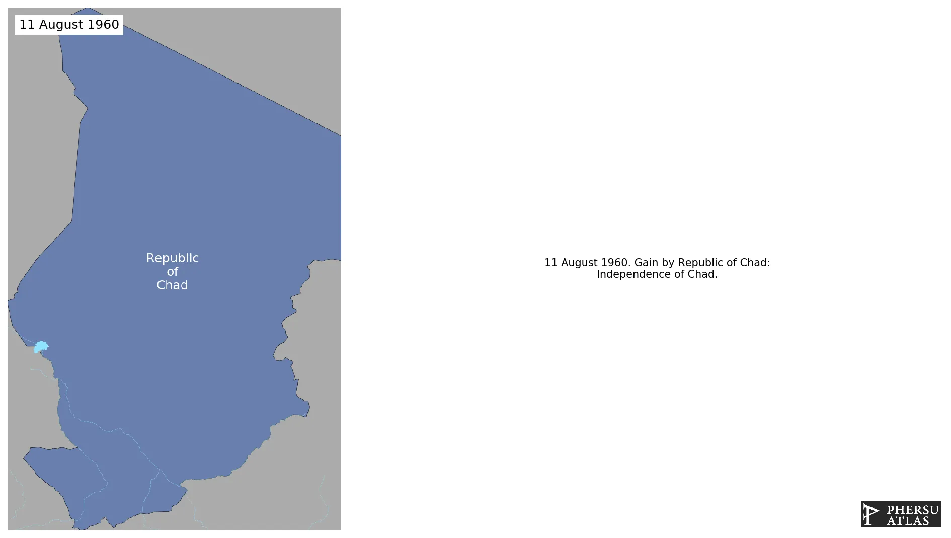
Is a landlocked country at the crossroads of North and Central Africa. It is bordered by Libya to the north, Sudan to the east, the Central African Republic to the south, Cameroon to the southwest, Nigeria to the southwest (at Lake Chad), and Niger to the west. It gained independence from France in 1960.
1. Genealogy

2. Maps of Political Control Over Time
 Republic of Chad : Map showing the initial year each territory was ruled by the polity
Republic of Chad : Maximal Extension of the Polity
Republic of Chad : Map showing the initial year each territory was ruled by the polity
Republic of Chad : Maximal Extension of the Polity
3. Administrative Divisions
4. Monthly Summaries

5. Lists and Timelines
6. Rankings
 Republic of Chad : Top wars ordered by largest reached area
Republic of Chad : Top wars by territorial gain or loss in terms of area of the changes
Republic of Chad : Top wars by territorial gain or loss in terms of area difference
Republic of Chad : Top wars ordered by largest reached area
Republic of Chad : Top wars by territorial gain or loss in terms of area of the changes
Republic of Chad : Top wars by territorial gain or loss in terms of area difference
7. Time Series
Republic of Chad : Time Series of all Territorial Changes
Republic of Chad : time series of its population and area throughout history
8. All Events mentioned in Territorial Changes

9. All Cities mentioned in Territorial Changes
 Abéché
Biltine
Fada
Abéché
Am Timan
Ati
Biltine
Bol
Bongor
Doba
Fada
Faya-Largeau
Kélo
Laï
Mao (Chad)
Mongo
Moundou
N'Djamena
Oum Hadjer
Pala
Sarh
Zouar
Bardaï
Fada
Faya-Largeau
Zouar
Fada
Faya-Largeau
Zouar
Bardaï
Abéché
Biltine
Fada
Faya-Largeau
Koro Toro
Abéché
Fada
Zouar
Fada
Fada
Ouadi Doum
Abéché
Faya-Largeau
Zouar
Ouadi Doum
Faya-Largeau
Fada
Faya-Largeau
Zouar
Koro Toro
Abéché
Fada
Faya-Largeau
Zouar
Faya-Largeau
Faya-Largeau
Abéché
Biltine
Fada
Abéché
Am Timan
Ati
Biltine
Bol
Bongor
Doba
Fada
Faya-Largeau
Kélo
Laï
Mao (Chad)
Mongo
Moundou
N'Djamena
Oum Hadjer
Pala
Sarh
Zouar
Bardaï
Fada
Faya-Largeau
Zouar
Fada
Faya-Largeau
Zouar
Bardaï
Abéché
Biltine
Fada
Faya-Largeau
Koro Toro
Abéché
Fada
Zouar
Fada
Fada
Ouadi Doum
Abéché
Faya-Largeau
Zouar
Ouadi Doum
Faya-Largeau
Fada
Faya-Largeau
Zouar
Koro Toro
Abéché
Fada
Faya-Largeau
Zouar
Faya-Largeau
Faya-Largeau