 Protectorate of Uganda: All Data
This page is about the data available for this polity; the chronology of its events is available here.
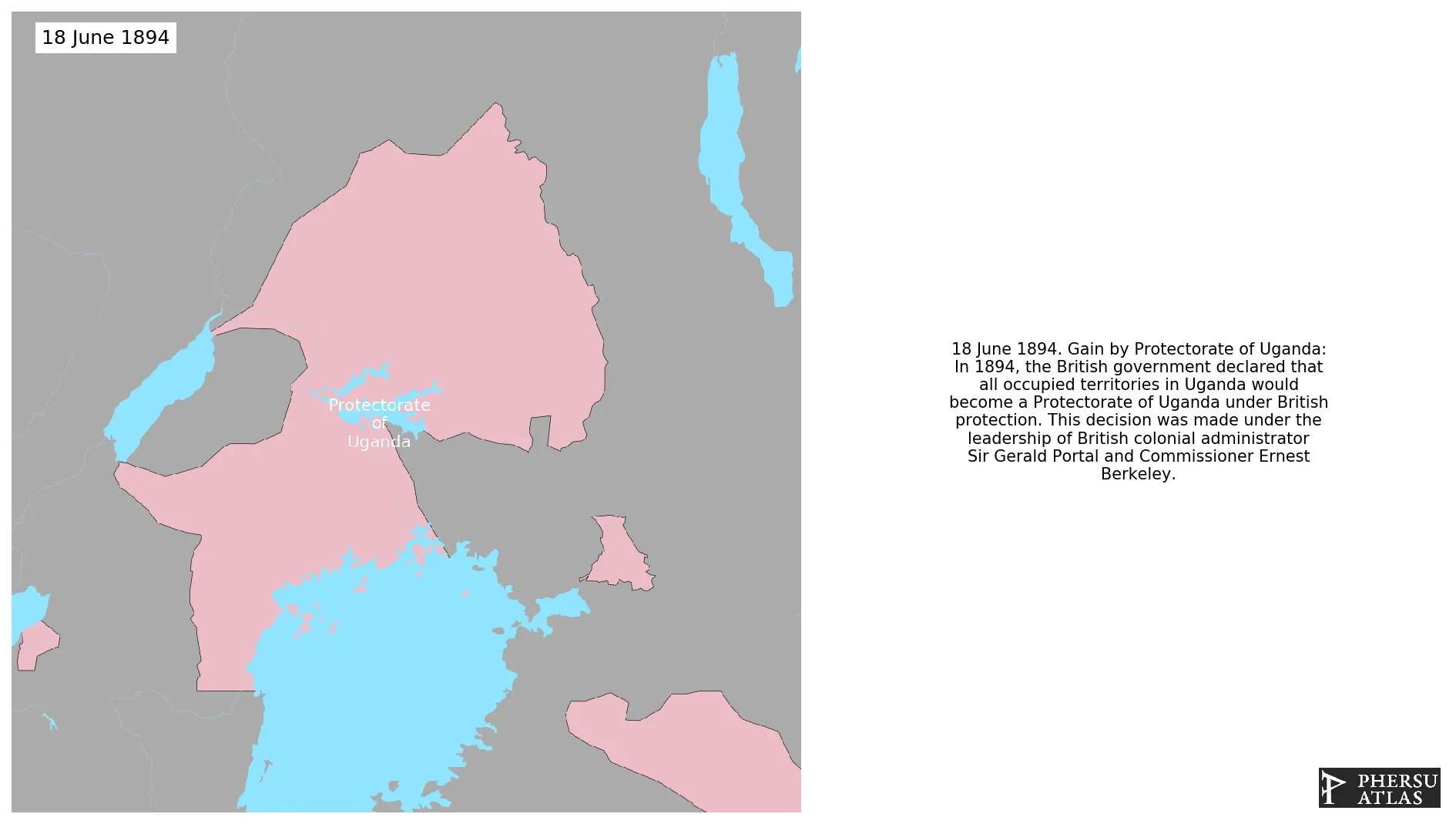
Was a protectorate of the British Empire from 1894. The colony became independent in 1963 as the Republic of Uganda.
1. Genealogy

2. Maps of Political Control Over Time
 Protectorate of Uganda : Map showing the initial year each territory was ruled by the polity
Protectorate of Uganda : Maximal Extension of the Polity
Protectorate of Uganda : Map showing the initial year each territory was ruled by the polity
Protectorate of Uganda : Maximal Extension of the Polity
3. Monthly Summaries

4. Time Series
 Protectorate of Uganda : Time Series of all Territorial Changes
Protectorate of Uganda : time series of its population and area throughout history
Protectorate of Uganda : Time Series of all Territorial Changes
Protectorate of Uganda : time series of its population and area throughout history
5. All Cities mentioned in Territorial Changes
 Bungoma
Chamagel
City of Kisumu
Eldama Ravine
Eldoret
Kakamega
Karungu
Kendu Bay
Kericho
Kisii
Kitale
Maralal
Naivasha
Nakuru
Adjumani
Arua
Nebbi
Pakwach
Gulu
Kaabong
Kaberamaido
Katakwi
Kitgum
Kumi Town
Moroto Town
Sironko
Soroti
Masindi
Masindi Port
Fort Portal
Kasese
Katwe
Iganga
Busia
Mbale
Pallisa
Tororo
Kapoeta
Mbarara
Kapoeta
Bombo
Entebbe
Jinja
Kalangala
Kampala
Kamuli
Kayunga
Kibaale
Kiboga
Lira
Masaka
Mityana
Mpigi
Mubende
Nakasongola
Lodwar
Adjumani
Arua
Bombo
Busia
Entebbe
Fort Portal
Gulu
Iganga
Jinja
Kaabong
Kabale
Kaberamaido
Kalangala
Kampala
Kamuli
Kasese
Katakwi
Katwe
Kayunga
Kibaale
Kiboga
Kisoro
Kitgum
Kumi Town
Lira
Masaka
Masindi
Masindi Port
Mbale
Mbarara
Mityana
Moroto Town
Moyo Town
Mpigi
Mubende
Nakasongola
Nebbi
Ntungamo
Pakwach
Pallisa
Sironko
Soroti
Tororo
Kabale
Kisoro
Arua
Moyo Town
Nebbi
Arua
Nebbi
Bungoma
Chamagel
City of Kisumu
Eldama Ravine
Eldoret
Kakamega
Karungu
Kendu Bay
Kericho
Kisii
Kitale
Lodwar
Maralal
Naivasha
Nakuru
Ntungamo
Bungoma
Chamagel
City of Kisumu
Eldama Ravine
Eldoret
Kakamega
Karungu
Kendu Bay
Kericho
Kisii
Kitale
Maralal
Naivasha
Nakuru
Adjumani
Arua
Nebbi
Pakwach
Gulu
Kaabong
Kaberamaido
Katakwi
Kitgum
Kumi Town
Moroto Town
Sironko
Soroti
Masindi
Masindi Port
Fort Portal
Kasese
Katwe
Iganga
Busia
Mbale
Pallisa
Tororo
Kapoeta
Mbarara
Kapoeta
Bombo
Entebbe
Jinja
Kalangala
Kampala
Kamuli
Kayunga
Kibaale
Kiboga
Lira
Masaka
Mityana
Mpigi
Mubende
Nakasongola
Lodwar
Adjumani
Arua
Bombo
Busia
Entebbe
Fort Portal
Gulu
Iganga
Jinja
Kaabong
Kabale
Kaberamaido
Kalangala
Kampala
Kamuli
Kasese
Katakwi
Katwe
Kayunga
Kibaale
Kiboga
Kisoro
Kitgum
Kumi Town
Lira
Masaka
Masindi
Masindi Port
Mbale
Mbarara
Mityana
Moroto Town
Moyo Town
Mpigi
Mubende
Nakasongola
Nebbi
Ntungamo
Pakwach
Pallisa
Sironko
Soroti
Tororo
Kabale
Kisoro
Arua
Moyo Town
Nebbi
Arua
Nebbi
Bungoma
Chamagel
City of Kisumu
Eldama Ravine
Eldoret
Kakamega
Karungu
Kendu Bay
Kericho
Kisii
Kitale
Lodwar
Maralal
Naivasha
Nakuru
Ntungamo