 Plurinational State of Bolivia: All Data
This page is about the data available for this polity; the chronology of its events is available here.
Bolivia is a landlocked country located in western-central South America. It is bordered by Brazil to the north and east, Paraguay to the southeast, Argentina to the south, Chile to the southwest and Peru to the west.
1. Genealogy

2. Maps of Political Control Over Time
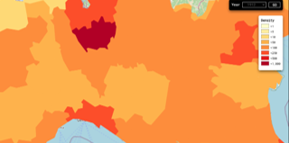
 Plurinational State of Bolivia : Map showing the initial year each territory was ruled by the polity
Plurinational State of Bolivia : Map depicting the polity's ruler in power when each territory was first controlled
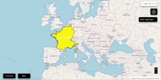
Plurinational State of Bolivia : Maximal Extension of the Polity
Plurinational State of Bolivia : Map showing the initial year each territory was ruled by the polity
Plurinational State of Bolivia : Map depicting the polity's ruler in power when each territory was first controlled
Plurinational State of Bolivia : Maximal Extension of the Polity
3. Administrative Divisions
4. Monthly Summaries

5. Lists and Timelines
6. Rankings
 Plurinational State of Bolivia : Top rulers ordered by largest reached area
Plurinational State of Bolivia : Top rulers by territorial gain or loss in terms of area difference
Plurinational State of Bolivia : Top rulers ordered by largest reached area
Plurinational State of Bolivia : Top rulers by territorial gain or loss in terms of area difference
7. Time Series
Plurinational State of Bolivia : Time Series of all Territorial Changes
Plurinational State of Bolivia : time series of its population and area throughout history
8. All Cities mentioned in Territorial Changes
 Achacachi
Aiquile
Apolo
Ascensión (Bolivia)
Baures
Bermejo
Betanzos
Camargo (Bolivia)
Camiri
Challapata
Charagua
Charaña
Cliza
Cobija
Cochabamba
Colcha K
Coro Coro
Coroico
Cuevo
Entre Ríos
Guayaramerín
La Paz (Bolivia)
Llallagua
Llica
Magdalena
Montero
Oruro
Padilla
Piso Firme
Portachuelo
Potosí
Puerto Acosta
Puerto Heath
Puerto Quijarro
Puerto Suárez
Puerto Villarroel
Punata
Quillacollo
Quime
Reyes
Riberalta
Roboré
Rurrenabaque
Sabaya
Samaipata
San Borja
San Carlos (Bolivia)
San Ignacio de Velasco
San Javier
San José de Chiquitos
San Lorenzo (Bolivia)
San Matías
San Rafael de Velasco
San Ramón (Bolivia)
Santa Ana del Yacuma
Santa Cruz (Bolivia)
Santa Cruz de la Sierra
Sica Sica
Sorata
Sucre
Tarabuco
Tarija
Trinidad (Bolivia)
Tupiza
Uncia
Uyuni
Vallegrande
Viacha
Villamontes
Villazón
Achacachi
Aiquile
Apolo
Ascensión (Bolivia)
Baures
Bermejo
Betanzos
Camargo (Bolivia)
Camiri
Challapata
Charagua
Charaña
Cliza
Cobija
Cochabamba
Colcha K
Coro Coro
Coroico
Cuevo
Entre Ríos
Guayaramerín
La Paz (Bolivia)
Llallagua
Llica
Magdalena
Montero
Oruro
Padilla
Piso Firme
Portachuelo
Potosí
Puerto Acosta
Puerto Heath
Puerto Quijarro
Puerto Suárez
Puerto Villarroel
Punata
Quillacollo
Quime
Reyes
Riberalta
Roboré
Rurrenabaque
Sabaya
Samaipata
San Borja
San Carlos (Bolivia)
San Ignacio de Velasco
San Javier
San José de Chiquitos
San Lorenzo (Bolivia)
San Matías
San Rafael de Velasco
San Ramón (Bolivia)
Santa Ana del Yacuma
Santa Cruz (Bolivia)
Santa Cruz de la Sierra
Sica Sica
Sorata
Sucre
Tarabuco
Tarija
Trinidad (Bolivia)
Tupiza
Uncia
Uyuni
Vallegrande
Viacha
Villamontes
Villazón