 Nicaragua (USA Protectorate): All Data
This page is about the data available for this polity; the chronology of its events is available here.
The United States occupation of Nicaragua from 1912 to 1933 was part of the Banana Wars, when the U.S. military invaded various Latin American countries from 1898 to 1934.
1. Genealogy

2. Maps of Political Control Over Time
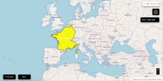
 Nicaragua (USA Protectorate) : Map showing the initial year each territory was ruled by the polity
Nicaragua (USA Protectorate) : Maximal Extension of the Polity
Nicaragua (USA Protectorate) : Map showing the initial year each territory was ruled by the polity
Nicaragua (USA Protectorate) : Maximal Extension of the Polity
3. Monthly Summaries

4. Lists and Timelines
5. Rankings
 Nicaragua (USA Protectorate) : Top wars ordered by largest reached area
Nicaragua (USA Protectorate) : Top wars by territorial gain or loss in terms of area of the changes
Nicaragua (USA Protectorate) : Top wars by territorial gain or loss in terms of area difference
Nicaragua (USA Protectorate) : Top wars ordered by largest reached area
Nicaragua (USA Protectorate) : Top wars by territorial gain or loss in terms of area of the changes
Nicaragua (USA Protectorate) : Top wars by territorial gain or loss in terms of area difference
6. Time Series
Nicaragua (USA Protectorate) : Time Series of all Territorial Changes
Nicaragua (USA Protectorate) : time series of its population and area throughout history
7. All Events mentioned in Territorial Changes

8. All Cities mentioned in Territorial Changes
 Bluefields
Boaco
Chinandega
Estelí
Granada (Nicaragua)
Jinotega
Jinotepe
Juigalpa
León (Nicaragua)
Managua
Masaya
Matagalpa
Ocotal
Puerto Cabezas
Puerto Lempira
Rivas
San Carlos (Nicaragua)
San Juan de Nicaragua
San Juan del Sur
Somoto
Bluefields
Boaco
Chinandega
Estelí
Granada (Nicaragua)
Jinotega
Jinotepe
Juigalpa
León (Nicaragua)
Managua
Masaya
Matagalpa
Ocotal
Puerto Cabezas
Puerto Lempira
Rivas
San Carlos (Nicaragua)
San Juan de Nicaragua
San Juan del Sur
Somoto
Bluefields
Boaco
Chinandega
Estelí
Granada (Nicaragua)
Jinotega
Jinotepe
Juigalpa
León (Nicaragua)
Managua
Masaya
Matagalpa
Ocotal
Puerto Cabezas
Puerto Lempira
Rivas
San Carlos (Nicaragua)
San Juan de Nicaragua
San Juan del Sur
Somoto
Bluefields
Boaco
Chinandega
Estelí
Granada (Nicaragua)
Jinotega
Jinotepe
Juigalpa
León (Nicaragua)
Managua
Masaya
Matagalpa
Ocotal
Puerto Cabezas
Puerto Lempira
Rivas
San Carlos (Nicaragua)
San Juan de Nicaragua
San Juan del Sur
Somoto