 Mining State of South Kasai: All Data
This page is about the data available for this polity; the chronology of its events is available here.
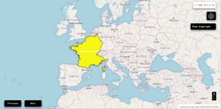
Less than a month after the Katangese secession, on 8 August, a section of the region of Kasai situated slightly to the north of Katanga also declared its autonomy from the central government as the Mining State of South Kasai (Sud-Kasaï) based around the city of Bakwanga.
1. Genealogy

2. Maps of Political Control Over Time
 Mining State of South Kasai : Map showing the initial year each territory was ruled by the polity
Mining State of South Kasai : Maximal Extension of the Polity
Mining State of South Kasai : Map showing the initial year each territory was ruled by the polity
Mining State of South Kasai : Maximal Extension of the Polity
3. Monthly Summaries

4. Lists and Timelines
5. Rankings
 Mining State of South Kasai : Top wars ordered by largest reached area
Mining State of South Kasai : Top wars by territorial gain or loss in terms of area of the changes
Mining State of South Kasai : Top wars by territorial gain or loss in terms of area difference
Mining State of South Kasai : Top wars ordered by largest reached area
Mining State of South Kasai : Top wars by territorial gain or loss in terms of area of the changes
Mining State of South Kasai : Top wars by territorial gain or loss in terms of area difference
6. Time Series
Mining State of South Kasai : Time Series of all Territorial Changes
Mining State of South Kasai : time series of its population and area throughout history

