 Honduras: All Data
This page is about the data available for this polity; the chronology of its events is available here.
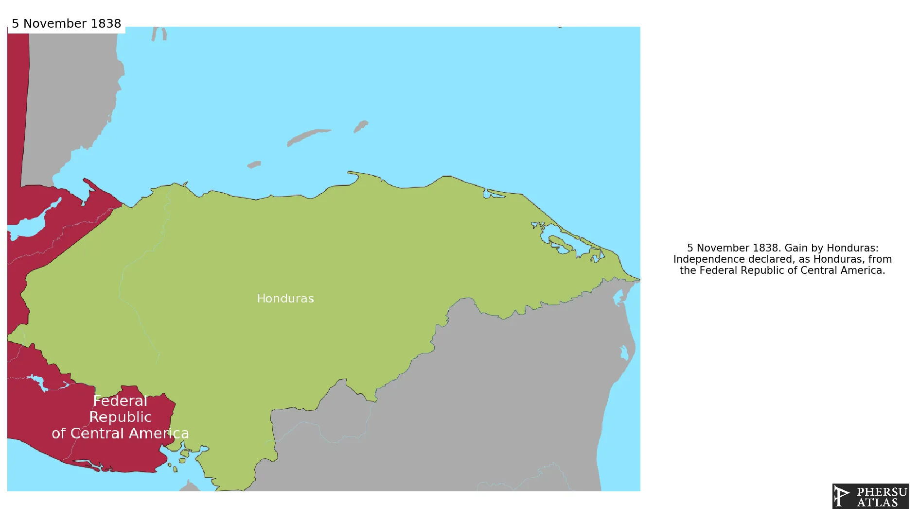
Is a country in Central America. Formerly part of the Spanish Empire in the America, Hondurasa became initially independent from Spain as part of the First Mexican Empire and then as part of the Federal Republic of Central America. It separated from the latter in 1838.
1. Genealogy

2. Maps of Political Control Over Time
 Honduras : Map showing the initial year each territory was ruled by the polity
Honduras : Maximal Extension of the Polity
Honduras : Map showing the initial year each territory was ruled by the polity
Honduras : Maximal Extension of the Polity
3. Administrative Divisions
4. Monthly Summaries

5. Lists and Timelines
6. Rankings
 Honduras : Top wars ordered by largest reached area
Honduras : Top wars by territorial gain or loss in terms of area of the changes
Honduras : Top wars by territorial gain or loss in terms of area difference
Honduras : Top wars ordered by largest reached area
Honduras : Top wars by territorial gain or loss in terms of area of the changes
Honduras : Top wars by territorial gain or loss in terms of area difference
7. Time Series
Honduras : Time Series of all Territorial Changes
Honduras : time series of its population and area throughout history
8. All Events mentioned in Territorial Changes

9. All Cities mentioned in Territorial Changes
 Brus Laguna
Choluteca
Comayagua
Gracias
Juticalpa
La Ceiba
La Esperanza
La Paz (Honduras)
Nacaome
Ocotepeque
Roatán
San Pedro Sula
Santa Bárbara (Honduras)
Santa Rosa de Copán
Tegucigalpa
Trujillo (Honduras)
Yoro
Yuscarán
Puerto Lempira
Ocotepeque
Alianza
El Amatillo
Goascorán
Aramecina
Caridad
Ocotepeque
San Marcos (Honduras)
La Labor
Alianza
El Amatillo
Goascorán
Aramecina
Caridad
Ocotepeque
Brus Laguna
Choluteca
Comayagua
Gracias
Juticalpa
La Ceiba
La Esperanza
La Paz (Honduras)
Nacaome
Ocotepeque
Roatán
San Pedro Sula
Santa Bárbara (Honduras)
Santa Rosa de Copán
Tegucigalpa
Trujillo (Honduras)
Yoro
Yuscarán
Roatán
Brus Laguna
Choluteca
Comayagua
Gracias
Juticalpa
La Ceiba
La Esperanza
La Paz (Honduras)
Nacaome
Ocotepeque
Roatán
San Pedro Sula
Santa Bárbara (Honduras)
Santa Rosa de Copán
Tegucigalpa
Trujillo (Honduras)
Yoro
Yuscarán
Puerto Lempira
Ocotepeque
Alianza
El Amatillo
Goascorán
Aramecina
Caridad
Ocotepeque
San Marcos (Honduras)
La Labor
Alianza
El Amatillo
Goascorán
Aramecina
Caridad
Ocotepeque
Brus Laguna
Choluteca
Comayagua
Gracias
Juticalpa
La Ceiba
La Esperanza
La Paz (Honduras)
Nacaome
Ocotepeque
Roatán
San Pedro Sula
Santa Bárbara (Honduras)
Santa Rosa de Copán
Tegucigalpa
Trujillo (Honduras)
Yoro
Yuscarán
Roatán