 Algeria: All Data
This page is about the data available for this polity; the chronology of its events is available here.
A country in North Africa. Algeria is bordered to the northeast by Tunisia; to the east by Libya; to the southeast by Niger; to the southwest by Mali, Mauritania, and Western Sahara; to the west by Morocco; and to the north by the Mediterranean Sea. It is considered part of the Maghreb region of North Africa.
1. Genealogy

2. Maps of Political Control Over Time
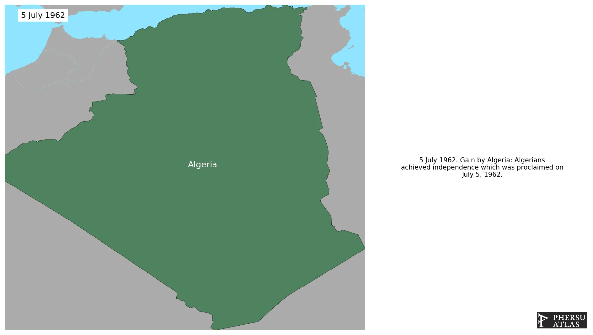
 Algeria : Map showing the initial year each territory was ruled by the polity
Algeria : Maximal Extension of the Polity
Algeria : Map showing the initial year each territory was ruled by the polity
Algeria : Maximal Extension of the Polity
3. Administrative Divisions
4. Monthly Summaries

5. Lists and Timelines
6. Rankings
 Algeria : Top wars ordered by largest reached area
Algeria : Top wars by territorial gain or loss in terms of area of the changes
Algeria : Top wars by territorial gain or loss in terms of area difference
Algeria : Top wars ordered by largest reached area
Algeria : Top wars by territorial gain or loss in terms of area of the changes
Algeria : Top wars by territorial gain or loss in terms of area difference
7. Time Series
Algeria : Time Series of all Territorial Changes
Algeria : time series of its population and area throughout history
8. All Events mentioned in Territorial Changes

9. All Cities mentioned in Territorial Changes
 In Amenas
Tindouf
Hassi-Beida
Tindjoub
Abadla
Adrar
Aïn Séfra
Algiers
Annaba
Arak (Algeria)
Batna
Béchar
Béjaïa
Béni Ounif
Biskra
Blida
Bordj Bou Arréridj
Bouïra
Chlef
Constantine
Constantine
Djanet
Djelfa
El Bayadh
El Goléa
El Oued
Ghardaia
Guelma
Hassi Messaoud
Illizi
In Amenas
In Amguel
In Salah
Jijel
Laghouat
Mascara
Médéa
Mostaganem
M'Sila
Oran
Ouargla
Oum El Bouaghi
Reggane
Saïda
Sétif
Sidi Bel Abbès
Skikda
Souk Ahras
Tamanrasset
Tébessa
Tiaret
Timimoun
Tindouf
Tizi Ouzou
Tlemcen
Touggourt
Hassi-Beida
Tindjoub
In Amenas
In Amenas
Tindouf
Hassi-Beida
Tindjoub
Abadla
Adrar
Aïn Séfra
Algiers
Annaba
Arak (Algeria)
Batna
Béchar
Béjaïa
Béni Ounif
Biskra
Blida
Bordj Bou Arréridj
Bouïra
Chlef
Constantine
Constantine
Djanet
Djelfa
El Bayadh
El Goléa
El Oued
Ghardaia
Guelma
Hassi Messaoud
Illizi
In Amenas
In Amguel
In Salah
Jijel
Laghouat
Mascara
Médéa
Mostaganem
M'Sila
Oran
Ouargla
Oum El Bouaghi
Reggane
Saïda
Sétif
Sidi Bel Abbès
Skikda
Souk Ahras
Tamanrasset
Tébessa
Tiaret
Timimoun
Tindouf
Tizi Ouzou
Tlemcen
Touggourt
Hassi-Beida
Tindjoub
In Amenas